TL;DR
NASA’s Earth Observatory released satellite images from 2025 that illustrate land- and water‑based impacts tied to human activity and a warming climate, from plankton blooms and shrinking lakes to more intense fires and floods. The collection also highlights renewable-energy developments, including a large floating solar array in India and a milestone year for global renewables.
What happened
Over the past year NASA’s Earth Observatory published satellite images that document a range of environmental changes linked in reporting to human activity and warming. Photos show a July plankton bloom in the Baltic Sea attributed to manure and fertilizer runoff; two hurricanes, Imelda and Humberto, approaching Florida amid research noting more simultaneous Atlantic storms as oceans warm; and Habaniya Lake in Iraq shrinking markedly between 2020 and 2025 amid a drought the source connects to warming and reports of historically low national water reserves. Imagery captured extreme March rainfall and consequent flooding in Queensland that killed 33 people, and false-color photos revealed large wildfire burn scars across South Korea and Los Angeles, events analyses said were made more likely and larger by warming. The set also includes human responses: a 210-acre floating solar array on India’s Narmada River reservoir and data showing renewables produced more power than coal in the first half of last year.
Why it matters
- Satellite imagery provides a broad, consistent view of environmental changes linked to human activities and climate trends.
- Visible impacts—shrinking lakes, larger fires, intense floods—underscore consequences for water security, infrastructure and public safety.
- The images juxtapose damage from warming with signs of energy transition, highlighting both risks and mitigation efforts.
- Trends visible from space can inform national and international policy, planning and disaster response priorities.
Key facts
- NASA’s Earth Observatory published a set of satellite images during 2025 showing environmental changes around the globe.
- A July plankton bloom in the Baltic Sea was attributed by scientists in the source to manure and fertilizer runoff from European farms.
- Hurricanes Imelda and Humberto were photographed approaching Florida; a recent study cited in the source found warming oceans are linked to an increase in instances of two or more Atlantic hurricanes forming simultaneously.
- Habaniya Lake in Iraq showed major shrinkage between 2020 and 2025; the drought affecting it is described in the source as fueled by warming, and Iraqi officials reported water reserves at an 80-year low in August.
- Extreme rainfall in Queensland in March produced the worst flooding the region had seen in half a century and resulted in 33 fatalities; the source says warming likely exacerbated the flooding.
- False-color imagery captured South Korean wildfires in March that burned close to 260,000 acres and killed 32 people; an analysis cited said warming doubled the odds of the weather conditions that produced the fires.
- Images of Los Angeles burn scars from the Palisades and Eaton fires followed a wet spring and unusually arid fall; a report cited in the source found warming made those fires twice as likely and 25 times larger, with more than 50,000 acres burned and an estimated 440 fatalities.
- A floating solar array completed earlier in the year on India’s Narmada River reservoir covers 210 acres, as shown in satellite imagery.
- According to the source, in the first half of last year renewables supplied more power than coal globally for the first time.
What to watch next
- Whether continued satellite monitoring will translate into new or accelerated policy actions at national or international levels — not confirmed in the source.
- Expansion of floating solar and other visible renewable installations captured from space and how quickly those footprints grow globally — not confirmed in the source.
- Further research and satellite records tracking the frequency of simultaneous Atlantic hurricanes and attribution studies tying multi-storm seasons to ocean warming — not confirmed in the source.
Quick glossary
- Satellite imagery: Photographs or sensor data of Earth taken from orbiting satellites, used to observe land, ocean and atmospheric conditions over time.
- Plankton bloom: A rapid increase in microscopic organisms in water bodies, often driven by nutrient inputs and environmental conditions.
- False-color image: An image that assigns visible colors to non-visible wavelengths or to emphasize specific features, commonly used to highlight vegetation, burn scars or other land-surface changes.
- Floating solar array: A photovoltaic power installation mounted on a body of water, designed to generate electricity while occupying reservoir or lake surfaces.
- Attribution study: Scientific analysis that assesses the extent to which human-caused climate change influenced a particular weather event or trend.
Reader FAQ
Were these images shared by NASA?
Yes. The collection was published by NASA’s Earth Observatory, according to the source.
Do the images prove climate change is causing these events?
The source reports that scientists and analyses linked warming to several events—such as increased odds for certain wildfires, drought impacts and more simultaneous Atlantic hurricanes—but it does not claim the images alone constitute definitive proof.
Did renewables generate more power than coal globally?
The source states that in the first half of last year renewables supplied more power than coal globally for the first time.
Is the floating solar array on India’s Narmada the largest in the world?
Not confirmed in the source.
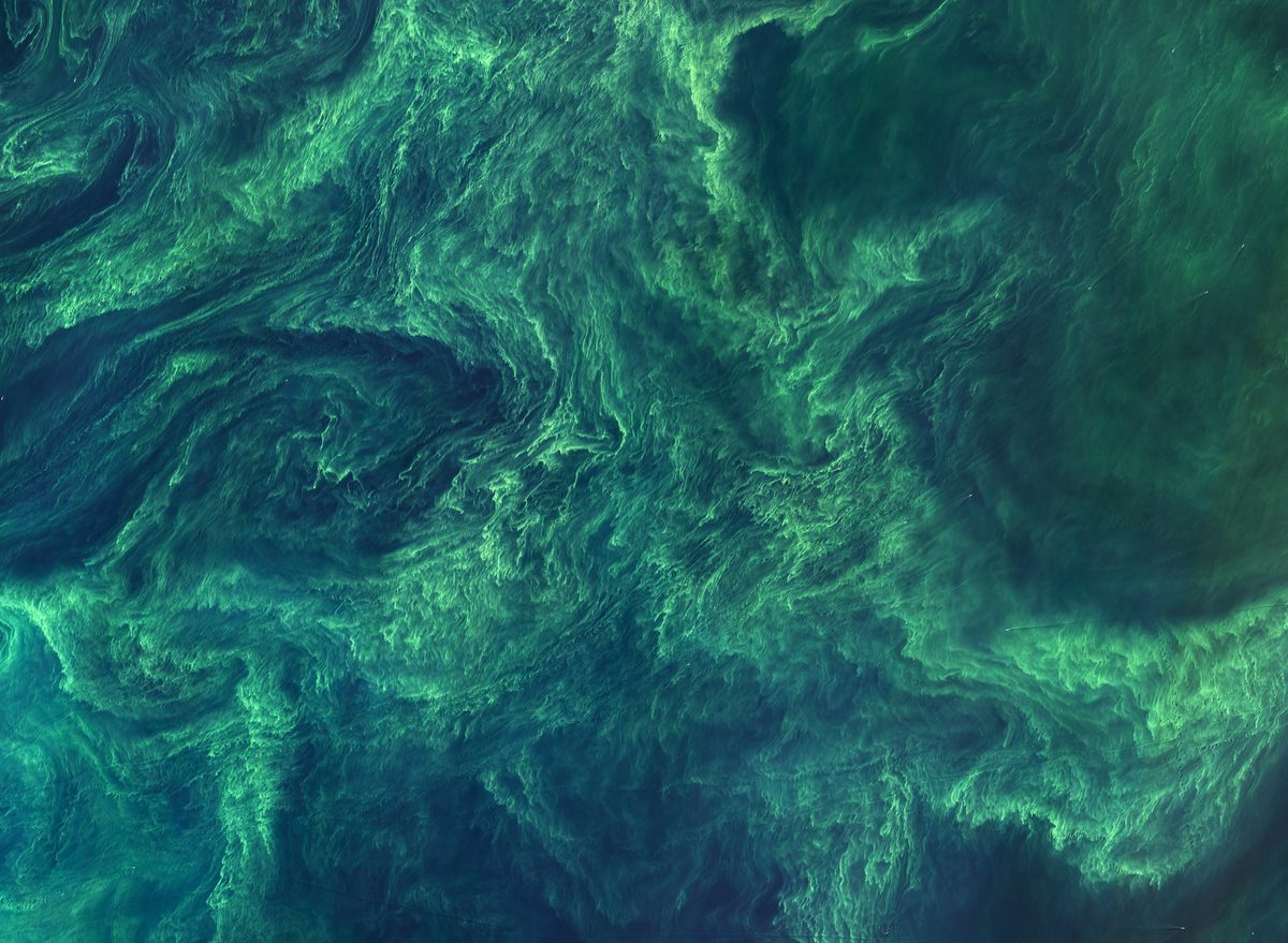
E360 DIGEST JANUARY 8, 2026 Our Changing Planet, as Seen From Space A plankton bloom in the Baltic Sea in July. Scientists say manure and fertilizer runoff from European farms…
Sources
- Our Changing Planet, as Seen from Space
- 2025: The View from NOAA Satellites | NESDIS
- 12 NASA Satellite Images That Tell the Story of Earth in 2025
- 2025 will be a year of slow but steady progress for climate …
Related posts
- A Practical, First-Hand Review of Go: What I Like and What I Don’t
- Is This the World’s First Solid-State Battery? CES Hype and Skepticism
- AI Coding Assistants Are Getting Worse, According to Recent Coverage