TL;DR
A new high-resolution satellite analysis finds that African forests and woody savannas shifted from a net carbon sink to a net source between about 2010 and 2017. The reversal was driven mainly by losses in tropical moist broadleaf forests while biomass gains in savannas partly offset the decline.
What happened
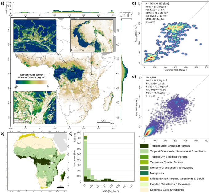
Researchers used recent satellite-derived maps of aboveground woody biomass, trained and validated with field plots and machine-learning models, to track changes across African biomes over roughly a decade. The study reports continent-wide biomass gains of about +439 ± 66 Tg yr⁻¹ from 2007–2010, followed by losses of −132 ± 20 Tg yr⁻¹ from 2010–2015 and −41 ± 6 Tg yr⁻¹ from 2015–2017. The biggest driver of the net decline was deforestation in tropical moist broadleaf forests. At the same time, many savanna areas showed biomass increases—likely linked to shrub encroachment—partially compensating the forest losses. The authors emphasise methodological advances (spaceborne LiDAR such as GEDI, radar like ALOS PALSAR, and high-resolution mapping at ~100 m) that made finer-scale attribution possible, but also note remaining uncertainties due to sparse field observations and validation metrics that vary by biomass level.
Why it matters
- A shift from sink to source increases the amount of CO2 emitted to the atmosphere, complicating efforts to meet the Paris Agreement targets.
- The study highlights the need for stronger action to halt deforestation, consistent with commitments such as the Glasgow Leaders Declaration.
- Accurate, high-resolution biomass maps improve the ability to detect where emissions from land-use change are occurring and to target conservation and restoration.
- Ongoing national climate pledges (NDCs) may need to be more ambitious to offset the loss of natural carbon removals reported here.
Key facts
- Study period and trend: Africa gained ~439 ± 66 Tg yr⁻¹ of aboveground biomass from 2007–2010, then lost −132 ± 20 Tg yr⁻¹ from 2010–2015 and −41 ± 6 Tg yr⁻¹ from 2015–2017.
- Primary driver: Deforestation in tropical moist broadleaf forests was the main cause of continental biomass decline.
- Partial offset: Biomass increases in savannas, likely from shrub encroachment, partially compensated forest losses.
- Mapping resolution: Aboveground woody biomass density maps were produced at ~100 m spatial resolution for 2017.
- Validation: Map comparison to field plots produced R² ≈ 0.70 (RMSD ≈ 74.2 Mg ha⁻¹) while comparison to airborne LiDAR for 2015–2016 showed R² ≈ 0.85 (RMSD ≈ 47.7 Mg ha⁻¹).
- Biome contrasts: Tropical moist broadleaf forests average roughly 396 Mg ha⁻¹ aboveground biomass density (locally up to ~429 Mg ha⁻¹), while savannas average about 45 Mg ha⁻¹.
- Regional role: African ecosystems contribute substantially to the global carbon cycle (source notes ~20% of global terrestrial carbon removals and substantial emissions from biomass burning and deforestation).
- Emissions from biomass burning and fuelwood use are significant in Africa (the source cites ~0.4 Pg C yr⁻¹ from some burning activities).
What to watch next
- Revisions to countries' Nationally Determined Contributions under the Paris Agreement and whether they increase ambition to compensate for lost natural sinks.
- Trends in tropical moist broadleaf forest loss and the effectiveness of policies aiming to halt deforestation (ongoing monitoring should show whether the 2010–2017 trend reverses).
- Improvements and continued deployment of high-resolution satellite missions (e.g., spaceborne LiDAR and radar) and expanded field-plot networks to reduce uncertainty in biomass change estimates.
Quick glossary
- Aboveground biomass (AGB): The mass of living plant material above the soil, usually expressed per unit area (e.g., Mg ha⁻¹); used to estimate carbon stored in vegetation.
- Carbon sink vs. carbon source: A carbon sink removes more CO2 from the atmosphere than it emits; a carbon source releases more CO2 than it absorbs.
- Tropical moist broadleaf forest: A biome characterized by dense, tall tree cover and high biomass density, typically found in humid tropical regions.
- GEDI (Global Ecosystem Dynamics Investigation): A spaceborne LiDAR instrument that measures forest canopy structure and helps estimate aboveground biomass.
- Shrub encroachment: The increase in woody shrub cover into grassland or savanna areas, which can raise local biomass but alters ecosystem function.
Reader FAQ
Did Africa’s forests definitely switch from a sink to a source?
According to this satellite-based analysis, the continental balance shifted from net biomass gains before 2010 to net losses between 2010 and 2017, indicating a transition from sink to source over that period.
What caused the change?
The authors identify deforestation of tropical moist broadleaf forests as the main driver, with savanna biomass gains only partially offsetting losses.
How certain are these results?
The study uses high-resolution satellite data and validation against field plots and airborne LiDAR, but notes uncertainties due to limited field observations and varying error metrics.
Will this automatically increase global emissions estimates?
Not confirmed in the source.
Download PDF Article Open access Published: 28 November 2025 Loss of tropical moist broadleaf forest has turned Africa’s forests from a carbon sink into a source Pedro Rodríguez-Veiga, Joao M….
Sources
- Loss of moist broadleaf forest in Africa has turned a carbon sink into source
- Loss of tropical moist broadleaf forest has turned Africa's …
- Africa's forests transformed from carbon sink to …
- Deforestation has turned Africa's forests from carbon sinks …
Related posts
- Handling Rust Errors Without External Crates: Patterns Using std Only
- No, it’s not a battleship — proposed ‘Trump’ warship resembles a large missile cruiser
- Victor LaValle’s subversive cosmic-horror novella The Ballad of Black Tom